Planning Retrieving Runs From
Outer Space
by Peter
Butterfield
January
2014
Measure
and Calculate the Distance of Runs (and other things) using your
Computer.
Whilst
driving in the countryside, have you ever looked across at an
unfamiliar field and thought “Hmm!
..that could make a nice run”,
and then returned home to survey your discovery using Google Maps or
Google Earth? Well
now, thanks to our friends at Google, you can take these voyeuristic
tendencies to a whole new level. Six hundred and eighty kilometres
above the Earth in fact, courtesy of the heavily subsidised GeoEye-1
land-imaging satellite and some clever geospatial data visualisation
software.
Google
likes to experiment with ideas all the time. A lot of stuff never sees
the light of day, while other things are set aside for people
who drill-down on sub-menus to see what they can find. One
such
repository of curiosities is Map Labs. A collection of beta-testing add-on
tools that are quietly made
available to the public for ‘de-bugging’ and
to assess potential before possible release into mainstream use.
One
particular Google Map add-on that is available at the moment is a ‘Distance Measuring Tool’
used for measuring the distance of a path on Earth. This tool allows
measurements to be plotted on screen between two or more points and can
be used measure practically any outdoor object from a farm gate to a
whole continent. One application that I use it for is locating and
planning suitable training runs for my dog. The tool makes it easy to
determine the length of ground needed for a run, overlaid to scale on
an image of actual terrain.
If you
haven’t played with this before, here’s how…
Firstly,
this only works in Google’s
Classic Maps.
If you’ve (been) switched to their New Maps program you will need to
switch
back to the Classic version. To do this, follow these Return to the Classic Google Maps
instructions.
Follow these steps:
1. Visit https://maps.google.com.au
2. Click the Maps Labs link at
the bottom of the left-hand panel.
 3. Click Enable for the Distance
Measurement Tool.
3. Click Enable for the Distance
Measurement Tool.
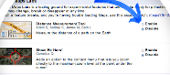 4. Click Save changes.
5. Search for a location then
scroll and zoom to the area of ground that you would like to measure.
4. Click Save changes.
5. Search for a location then
scroll and zoom to the area of ground that you would like to measure.
 6. Click the ruler icon at the
lower left-hand corner of the map.
6. Click the ruler icon at the
lower left-hand corner of the map.
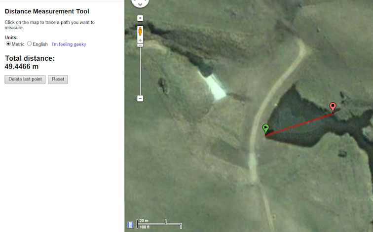
 7.
Click your starting point on the map, then click your destination
point. A red path will appear on the map between the two locations, and
the distance will be shown in the left panel.
7.
Click your starting point on the map, then click your destination
point. A red path will appear on the map between the two locations, and
the distance will be shown in the left panel.
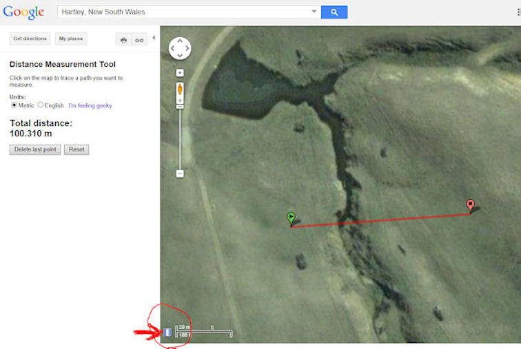 Map 1. Remember to
click the Ruler icon to start.
Map 1. Remember to
click the Ruler icon to start.
Once
you have plotted a line you can easily increase, decrease or move the
angle of the line by simply placing your cursor over one of the flags,
holding down the mouse button, and dragging the flag around. Note that
the distance between the two points in the left hand panel changes as
you move. Release the mouse button when you are happy with the line.
Move the cursor and press again to extend the line in a new direction
if you want (e.g. to plot around an obstacle like a tree or boulder,
etc). If you are unhappy with your line, simply click the Reset button
under the measurement. Remember, at all times, you can zoom in or out
by using your scroll wheel or moving the zoom bar on screen. Note that
you can choose between two different units: Metric or Imperial
(English). If you really want to impress your friends, hit the “I’m feeling geeky”
link next to the measurements.
Living
in a city, I particularly like to use this tool to help work out if a
park or reserve has enough ‘quiet’ area to set a training run for a
mark or blind in. Occasionally, I cheekily use it to check the length
of a run set by a Judge. Invariably, they are always better judges of
distance than I give them credit
for!
Now
I know what you’re thinking, and before I get bucket loads of mail I am
not suggesting that this is an accurate means for determining the
precise length of runs for trials. In fact, over 100 – 150 meters of
heavily undulating terrain this tool’s estimates can fall significantly
short of reality as it simply reports the distance a crow flies from point-to-point.
An experienced eye and pacing out over actual grounds will always be
the superior method. However, if you like to plan things in advance,
and need to
set some runs in foreign terrain, then this tool does have potential to
provide you with some perspective and could lead to saving
precious
time when setting-up a new location.
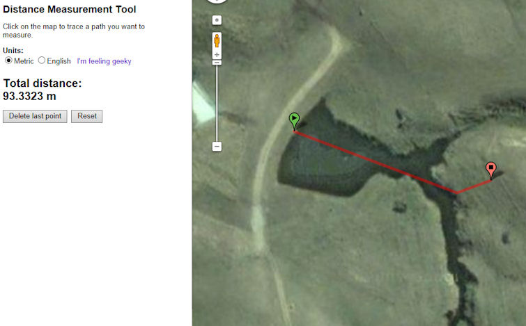
Aside
from land, this is a highly effective method for estimating the
diagonal length of travel across bodies of water such as creeks or
dams, and for contemplating alternative entry and exit points.
As
your skills and addiction to this tool grow, you will find that it can
be applied to non-retrieving things as well. Like working out the size
of your neighbour’s pool for example, or perhaps…well I’ll leave it to
you.
There
are commercial alternatives to this program available such as NearMap
that use aerial photography instead and have more features. Their
images are more up-to-date also,
but they charge an arm and leg to subscribe to and generally have
poorer resolution in rural areas than Google. A
closing word of caution – like most free computer
things these days, this
tool could change or disappear altogether at anytime. So if you like
it, make the most of it while you can.
 Map 2.
Useful for measuring distances across water
Map 2.
Useful for measuring distances across water.
Map
3. Bending the path is possible to allow for obstacles or steep
undulations, but always treat the reported distance as a guide
only.
©
This
page is provided by Working Gundog Club Inc.
(Affiliated with Dogs NSW)